Aug 15, 2025
El Niño 2026 and Changing Climate: Compounding Risks for Western Australia's Peel-Harvey Estuary System
Auther Name comes here



The Bindjareb Djilba, also known as the Peel-Harvey Estuary, lies within the traditional Country (boodja) of the Bindjareb (Pinjarup) Noongar people. Djilba is an ancient name, used for thousands of years, and carries multiple meanings within Noongar culture. It refers to one of the six Noongar seasons, falling between August and September, a period that bridges western European winter and spring. It is also the Noongar name for bream, a fish closely tied to the estuary.
According to Noongar tradition, the Peel-Harvey estuary and all connected rivers and lakes were formed during the Dreamtime, at a time when drought had begun to dry up the land's freshwater sources. The Woggaal, the Noongar creator, is associated with the creation of freshwater places. The female aspect of the Woggaal, called Maadjit, travelled inland from the sea to give birth to her children, and in doing so, created the Peel Inlet. The rivers, streams, lakes, wetlands, and springs surrounding the estuary were formed by Maadjit's children, known as koolaangka, as they moved across the land and left their marks. The remaining waterways were shaped by Maadjit herself as she searched for her children.
The name Djilba carries values of renewal and new beginnings, reflecting the spirit of spring. Some Noongar groups also specifically associate Djilba with the "second rains" that refill lakes and waterholes. The bream, which are abundant in south-west waterways including the Peel-Harvey, begin to spawn in the estuary around spring, adding another layer of meaning to the season's name.
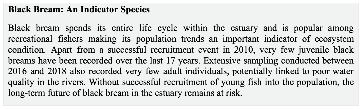
The connection between Djilba as a season and the Dreamtime creation story is deeply coherent. Maadjit's children were born during a drought, and through their movement across the land, new freshwater sources were created, restoring the fertility of the country. The cultural meaning of Djilba is also reflected in the life cycle of bream. They have long been a key food source for Noongar people, they begin to spawn during the sixth Noongar season, and unlike many estuary species, they live their entire lives within the estuary, with the shifting balance of salt and fresh water shaping their movement and life cycles throughout.
In recognition of Maadjit, the Murray River carries her name, called Bilya Maadjit, meaning River of the Female Creator. The bridge at the point where the Kwinana Freeway meets the Forrest Highway has also been named Bilya Maadjit in her honour.
This cultural context is important because the health of Peel-Harvey Estuary is not only an environmental, ecological or economic concern, but it is also deeply connected to the cultural values, intergenerational knowledge systems and custodial responsibilities that have sustained boodja for thousands of years.
1 . Introduction
The Peel-Harvey Estuary in south-western Western Australia is among the state's most ecologically and economically important estuarine systems. Listed as a Ramsar wetland in 1990, it supports commercial and recreational fisheries, aquaculture, eco-tourism, and irrigation while simultaneously serving as a sink for nutrient runoff from an intensively farmed catchment. Located near Mandurah, the estuary spans approximately 136 km² and receives freshwater from the Serpentine, Murray, and Harvey rivers before mixing with marine waters from the Indian Ocean through the natural Mandurah entrance and the Dawesville Cut, an artificial channel opened in 1994.
The estuary and its surrounding habitat hold international recognition for their high ecological value, supporting a wide range of species, including native fish, birds, aquatic invertebrates, and dolphins, that rely on the system for habitat, food, shelter, and reproduction. It is classified as a high-conservation-value aquatic ecosystem and is listed in the Directory of Important Wetlands in Australia.
The estuary holds international significance for waterbirds and migratory wading birds and is acknowledged as a ‘wetland of global importance.’ The bird species (djerap) that inhabit the estuary can be categorized into seven primary types, each with distinct habitat preferences and dietary needs: ducks (yerderap) and small grebes; macrophyte feeders; fish eaters; Australian shorebirds; International shorebirds; large wading birds; and other birds that rely on wetland environments. Since the 1980s, these seven categories have been represented by a total of 104 species.
The estuary also functions as a nursery, breeding, and feeding ground for blue swimmer crab (Portunus armatus) and western king prawn (Penaeus latisulcatus). It supports around 70 fish species including marine species such as King George whiting, sea mullet, tailor and whitebait, as well as estuarine species such as black bream and estuary cobbler. The estuary additionally serves as a key migratory pathway for pouched lamprey (Geotria australis).
Several areas of the estuary support a high diversity of benthic macroinvertebrates, organisms such as shrimp, worms, and bivalves living in or on the sediment. These species are essential to ecosystem function, decomposing organic matter and recycling nutrients, and serve as a major food source for fish and birds. However, studies found that the macroinvertebrate communities currently present in the Peel-Harvey Estuary are predominantly environmentally tolerant species. This is important because in a healthy ecosystem, there is usually a mix of both sensitive and tolerant species. When only tolerant species are present, it suggests that the environment is under stress. In areas with high nutrient and organic matter loads, macroinvertebrate communities are severely degraded, and some areas are entirely devoid of invertebrate fauna.
Economically, the estuary attracts an average of 2.9 million visitors per year, predominantly day-trippers engaged in boat and shore-based fishing, water sports, crabbing, dolphin and birdwatching, camping, canoeing, swimming, and picnicking. With approximately 11,500 recreational boats registered in Mandurah alone, the Peel-Harvey is central to the region's recreation, tourism and broader blue economy.

What’s happening right now? Official climate agencies, globally, now indicate that El Niño is underway in the tropical Pacific and is likely to strengthen through the year. For the Peel-Harvey region, the concern is not only reduced rainfall or hotter conditions in isolation but also the way climate stress can interact with existing pressures: nutrient enrichment, low dissolved oxygen, hypersalinity, harmful algal blooms, fish kills, declining freshwater inflows, and tourism and urban development, significant for the Blue-Economy of the region
Different forces at-play in the region: Western Australia (WA) is unique in that El Niño does not markedly raise the odds of dry conditions the way it does in the eastern states; rather, it is the Indian Ocean Dipole (IOD) climate driver, together with the strength of the Leeuwin Current, that most strongly modulates winter rainfall and near-shore sea-surface temperatures along the WA coast. The water temperatures off the WA coast are predominantly determined by the Leeuwin Current, which flows southward from Indonesia.
This Leeuwin current is the only subtropical boundary current that moves towards the pole on the eastern side of an ocean basin. The existence of this current is a result of the "gap" between Australia and Indonesia, which connects the Indian and Pacific Oceans. The easterly winds over the Pacific Ocean lead to the accumulation of warm water on the ocean's western side, which causes an increase in sea level across the Indonesian archipelago. This rise in sea level is then transmitted along the western Australian coast, creating pressure differences that draw in warm water and push it south, thereby generating the Leeuwin Current. During La
Niña years, this current becomes stronger, resulting in the southward movement of warmer water. In contrast, during El Niño years, the current weakens, causing a decrease in ocean temperatures. As a result, in many regions of Western Australia, El Niño does not significantly alter the likelihood of dry conditions, unlike in the eastern states.
2 . The 2026 El Niño and Associated Climate Signals
The Australian Bureau of Meteorology has officially confirmed the onset of an El Niño in Australia, which refers to an extended period of warmer-than-usual water in the central and eastern Pacific. Forecast models anticipate a moderate to strong El Niño event, based on the magnitude of warming observed in the central tropical Pacific. Although the Indian Ocean Dipole (IOD) is currently neutral, models still suggest the potential development of a positive IOD during winter; this combination with El Niño would likely increase the risk of dry conditions across southern and eastern Australia.
Sea surface temperature analysis for the week ending 14 June 2026 shows water temperatures along most of the Australian coast are average or higher. Furthermore, regional climatic data recorded since January 2026 reveals a trend of drier than average across parts of Western Australia, with distinct impacts observed in the south-western corner.
The Bureau of Meteorology’s latest long-range forecasts for Western Australia (July-September) indicate:
A 60-80% chance of below-average rainfall for the South West Land Division of Western Australia.
A 40-70% increased chance of unusually low rainfall across parts of south-west Western Australia.
There is a more than 60% chance of unusually high maximum temperatures across most of Western Australia and the likelihood is even greater, exceeding 80% in western parts of Western Australia.
There is a greater than 60% chance of high minimum temperatures across much of the southern two-thirds of Western Australia.
In other words: hotter, drier conditions are likely coming, but will be varied across the landscape.
3 . The Peel-Harvey Estuary: Already Under Pressure
The Peel-Harvey Estuary, the largest inland water body in south-western Australia, is no stranger to the climatic challenges but it becomes important to understand the unique geographic positioning of the estuary to grasp what makes it complex and dynamic to begin with.
The Peel-Harvey Estuary, located 75 km south of Perth, comprises two connected shallow basins: the Peel Inlet and the Harvey Estuary, together with the lower reaches of three rivers, which are strongly influenced by seawater that moves upstream with the tide. The estuary is classified as microtidal, with a tidal range not exceeding 1 m.
The Serpentine and Murray Rivers feed into Peel Inlet, while the Harvey River feeds into Harvey Estuary. Together with about 15 major drains, these three rivers bring strong seasonal flows into the system, with approximately 80% of total annual discharge occurring between May and October. Peak discharge across all three rivers occurs in August, with the Murray River contributing the greatest volume, followed by the Harvey River and then the Serpentine River. Minimum flows are typically recorded in February or March. River-drainage is the critical part of estuarine health as it brings freshwater and other nutrients to the feature.
3.1 Estuarine Water Quality
The Department of Water and Environmental Regulation indicates that while the Peel Inlet exhibits good water quality, the Harvey Estuary is poorly flushed, leading to hypersaline conditions during the summer months and episodic algal blooms.
Historically, tidal exchange was restricted through a long, narrow mouth at Mandurah. As agriculture and fertiliser usage increased in the catchment, nutrients progressively accumulated and the estuary first responded with benthic macroalgal overgrowth and later with seasonal blooms of toxic blue-green algae Nodularia spumigena.
The 1994 opening of the Dawesville Cut was the major engineering intervention for the purpose of reducing these algal bloom issues by enhancing the mixing of higher salinity waters from the coast with the inlet and estuary. However, algal blooms remain a concern in certain areas of the system, resulting in anoxic or hypoxic conditions. The frequency and levels of potentially harmful microalgal species are higher in the Peel-Harvey estuary compared to most other estuaries in the southwest. At the same time, seawater flushing through the Dawesville Channel pushes the estuary toward hypersalinity in dry seasons, leaving only highly salt-tolerant organisms able to survive.
For the Estuary, the Serpentine River has extremely high nutrient levels, promoting microalgal growth throughout the year, with frequent occurrences of potentially harmful microalgae. The Murray River carries persistently low bottom-water oxygen, with occasional microalgal blooms and fish kills. Over the past 15 years, river flows into the estuary have decreased by about 33% due to declining rainfall associated with climate change, which has impacted the movement of nutrients and other contaminants while prolonging water residence time within the estuary. Nutrient inputs from both the catchment and estuarine areas accumulate in the lower rivers and basins, worsening eutrophication and creating favourable conditions for algal blooms and fish kills. Furthermore, the decrease in river flow attributed
to climate change (resulting from reduced rainfall) and rising sea levels leads to the salt wedge extending further upstream, increasing water stratification. This stratification, especially when dissolved oxygen levels are low, can trigger the release of even more nutrients from the sediments. Estuary monitoring becomes critical here, especially on forecasting when these events would occur and where.
3.2 Catchment Nutrient Sources
Phosphorus and nitrogen are two key elements which contribute most to the nutrient led issues in the region. The Peel-Harvey catchment's sandy soils readily leach phosphorus and nitrogen into the drainage network. Mostly, human-induced changes in land-use such as Beef farming is responsible for the majority of nutrient runoff into the Peel-Harvey estuary, despite accounting for only 11% of the total catchment area. Cropping is the second largest land use in the catchment, representing 38% of the area. It contributes 12% of the nitrogen but a mere 1% of the phosphorus to the estuary, primarily because it is situated in the upper catchment region. The relatively lower phosphorus contribution from cropping can be attributed to the more retentive soils found in the upper catchment.
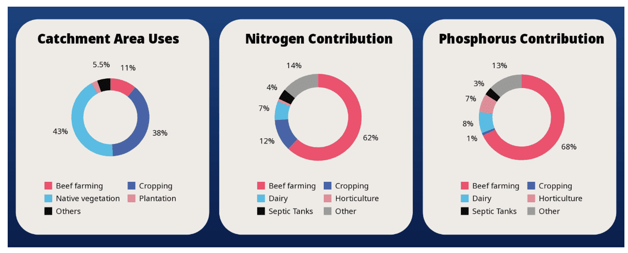
These land uses are all located on the coastal plain, characterized by its wet conditions, significant artificial drainage, and widespread soils that have low nutrient retention capability. It becomes imperative to be able to locate the drainage and run-off patterns of these nutrients to identify the areas of highest concern and then deploy solutions to control or address them.
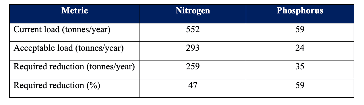
Table 1: Current and acceptable nitrogen and phosphorus loads for the Peel-Harvey Estuary from the coastal plain part of the catchment (Source: Gabi Warlang Bidi Water Quality Improvement Plan for the Peel-Harvey Estuary, 2025)
3.3 The ‘Pea-soup’ Problem: Algal Community Composition
When you have a water-body as dynamic as the Peel-Harvey, where it is a mix of saline and freshwater environment, rich in nutrients : Algal issues are bound to happen. It is important to highlight here that algae is fundamental to an ecosystem's health. The problem arises when we have too many of them or too few; of few or combination of them.
The phytoplankton assemblage of the Peel-Harvey comprises eight major groups: Chlorophyta, Diatoms, Cyanophyta, Dinophyta, Cryptophyta, Haptophyta, Chrysophyta, and Raphidophyta, of which five contain species toxic to humans and aquatic life.
The Serpentine River has historically and currently been dominated by chlorophytes, diatoms, and cyanophytes, with cyanophyte densities periodically reaching densities where the water resembles pea soup, with many species capable of producing toxins.
The estuarine reaches of the Murray River carry high densities of dinophytes (dinoflagellates), taxa characteristic of stratified waters, which can collapse into harmful blooms during periods of warm, calm conditions.
3.4 Fisheries under Climate Stress
Fish kills are one of the most visible warning signs that a system is under stress, but they typically mark the end of a longer process of declining water quality. On average, the Peel-Harvey Estuary has experienced one fish kill event per year since 1999 (Department of Water and Environmental Regulation, 2023). These have occurred most frequently in the estuarine reaches of the Murray and Serpentine Rivers, where a combination of factors creates dangerous conditions: persistent nutrient loading, seasonal water stratification that traps low-oxygen bottom water, high organic matter inputs and seasonal to frequent algal blooms.
Between April 2016 and September 2020, the Department of Water and Environmental Regulation (DWER) recorded 21 fish kills across all Healthy Estuaries WA catchments. Out of which, more than half (13 out of 21) occurred within the Peel-Harvey catchment, predominantly in the lower reaches of the Serpentine and Murray Rivers. These events were generally attributed to poor water quality, particularly low dissolved oxygen concentrations.
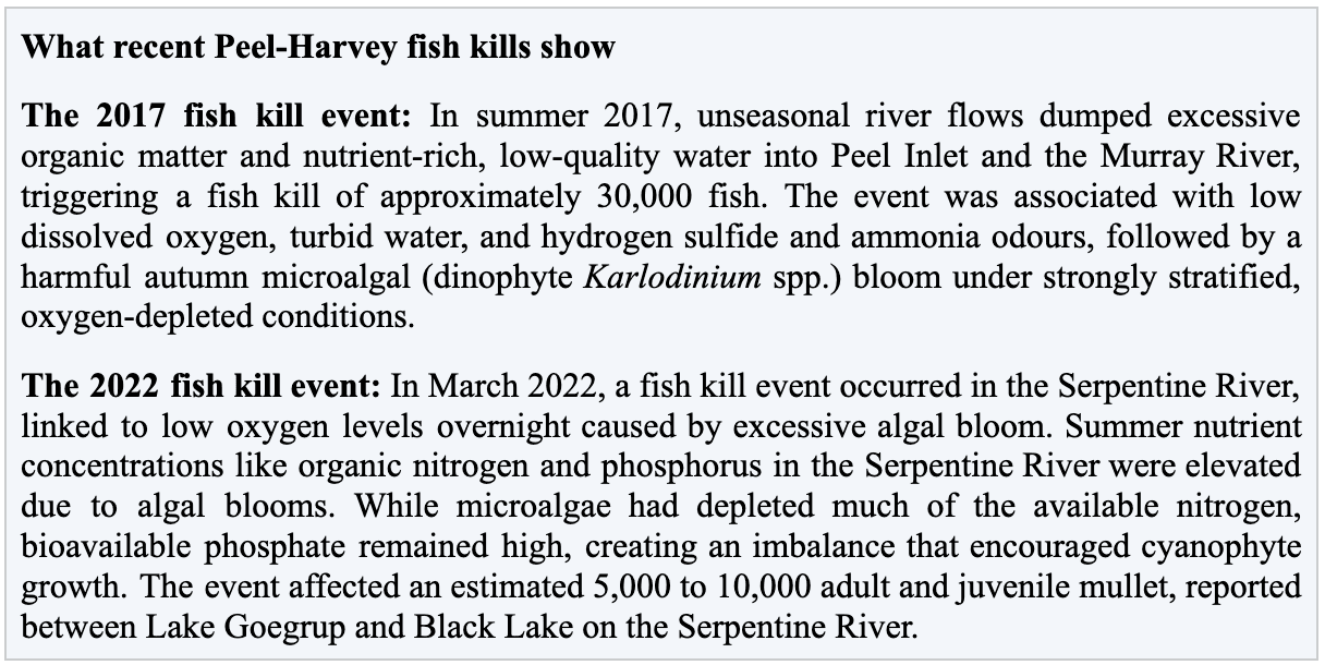
Fish Community Index assessment conducted in 2017-18 found that the estuary generally performed poorly. Fish community condition was weakest in the shallower waters of the Peel Inlet, the Mandurah Channel, the deeper waters of eastern Peel, and the Serpentine and Murray rivers, all of which received a D score. Conditions were slightly better in the Harvey Estuary and the shallower sections of the Serpentine and lower Murray River, which received a C score. The best fish community condition was recorded in the deeper areas of the western Peel Inlet, northern Harvey Estuary, and the shallow waters of the upper Murray River, which received a B score.
3.5 Why This Matters Economically
Annually, the Peel Harvey Waterways contribute approximately $605.7 million to the economy, which sustains over 2,000 full-time equivalent jobs in Western Australia.
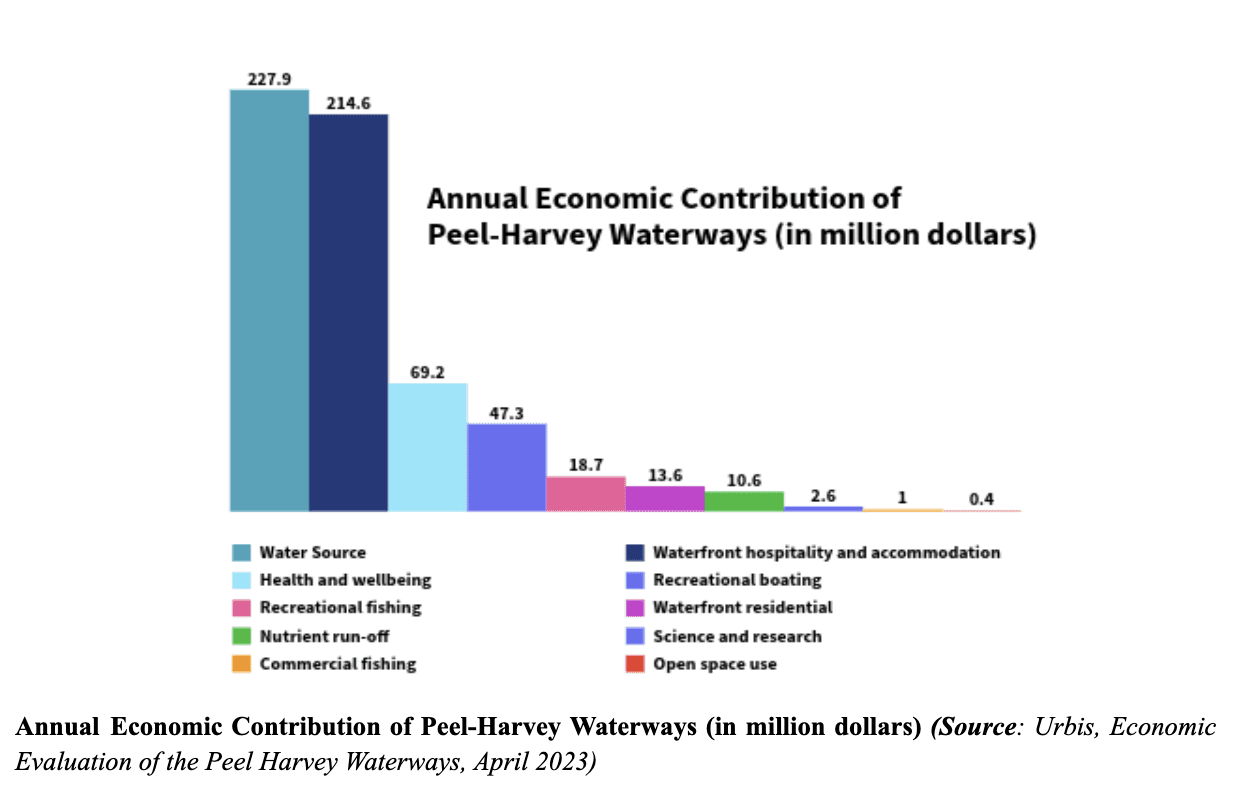
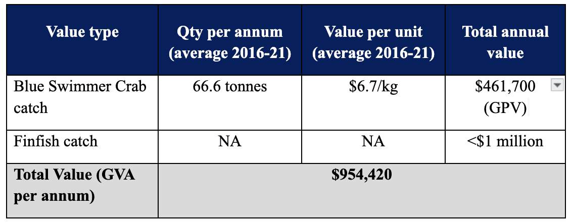
Commercial fisheries: Blue swimmer crab and western king prawn both depend on Peel-Harvey nurseries. They represent a significant export industry. The Peel-Harvey Estuary supports the largest commercial crab fishery in south-western Western Australia, with annual catches ranging between 36 and 72 tonnes. In addition, the estuary’s commercial finfish catch is estimated at 100 to 130 tonnes per year, all of which is sold within Western Australia.
Table 2: Economic Value of Commercial Fishing Activity (Source: Urbis, Economic Evaluation of the Peel Harvey Waterways, April 2023)
Recreational fishing: Of the estimated 619,000 fishers in Western Australia, around 9% are based in the Peel region. With each fisher undertaking an average of 5.3 trips per year, the estimated 55,152 fishers in Peel generate approximately $21.7 million in economic activity annually. This expenditure contributes an estimated $18.7 million per year in Gross Value Added (GVA) impact.
Recreational boating: 11,500 recreational boats are registered in Mandurah alone, making it one of Australia's premier waterways for boating and fishing. The average expenditure per trip for recreational boating has been identified as $565, with boaters making around 9 trips each year. This estimate of spending encompasses costs such as vessel maintenance, berth fees, fuel, equipment, and vessel registration but does not include the cost of the vessel itself. Thus, it is reasonable to conclude that all these expenses are retained within the region as they are tied to the PHW. Based on these assumptions, the total annual spending comes to $54.8 million, translating to an uplift of $47.3 million in Gross Value Added (GVA) for the Western Australian economy.
Tourism: The estuary attracts 2.9 million visitors annually for fishing, water sports, dolphin-watching, birdwatching, and camping. The Mandurah area is the fastest-growing city in WA and the second-fastest-growing regional city in Australia – its future depends on water quality.
Ecological value: The estuary supports dolphins, 70+ fish species, aquatic birds, and is listed internationally as a Ramsar wetland (a wetland of global significance).
If algal blooms persist, fish kills increase, and water quality declines, all of this economic and ecological value is at risk.
4 . Real-Time Water Monitoring is Not Optional in This Environment
The Peel-Harvey Estuary illustrates a broader truth about climate-stressed water bodies: conventional monitoring, periodic manual sampling, annual water quality reports cannot keep pace with the dynamics such an extreme climatic event introduces. In such a rapidly changing estuarine system, the larger value lies in prediction: identifying the probability of risk before the algal bloom, fish kill, or oxygen crash occurs.
When an algal bloom is developing or oxygen levels are crashing, waiting weeks or months for results means missing the window for intervention. Fish kills happen within hours or days, not months. Additionally, traditional monitoring whether by manual sampling or sensor-based gauges only gives you a snapshot of conditions at the moment of sampling or based on the accuracy of the sensor deployed for a single point in many hectares of water-body. It doesn't tell you what conditions are for the whole system, which areas need focus and what it will be like next week, or whether an algal bloom is developing before it becomes visible.
This is where new tools such as AI-based sensing can assist and introduce a paradigm shift in how we manage and understand our key water-resources.
5. The Peel-Harvey EstuarySense System : AI for Estuary Resilience
Imagine having a "virtual replica" of the Peel-Harvey Estuary – that shows in real-time the continuous changes on the estuary similar to how one accesses the weather information, but here for water quality and quantity data, capable of showing you what's happening right now and what's likely to happen over the next weeks. That's exactly what we build at EstuarySense Project powered by the NatureDots AquaNurch Digital Twin foundation model and is currently live for the Peel-Harvey’s 7200 ha area (72 km²), spearheaded by the Shire of Murray’s Food Innovation Precinct WA (FIPWA) and Peel Development Commission with support from DWER.
It's built on advanced artificial intelligence (AI) that learns from past patterns and current conditions to train itself on different water-ecosystem dynamics, learns as it gets deployed and fine-tunes itself.
A live AI-powered real-time monitoring and prediction system supporting regional resilience by providing 1000 times more water quality and quantity data than conventional monitoring while needing about 60% less hardware, IoT infrastructure, or manual data collection to do it. Generating hyperlocal, real-time intelligence on the ecosystem dynamics with a predictive intelligence horizon ranging from a few hours to a week or 200 days; with simulation and anomaly detection on-fly so as to enable different key stakeholders with decision-grade intelligence for actionable informed intervention and proactive management responses.
EstuarySense is intended to strengthen ecosystem stewardship, make more effective use of existing resources, reduce risks and safeguards the long-term resilience of one of WA’s most important estuarine systems.
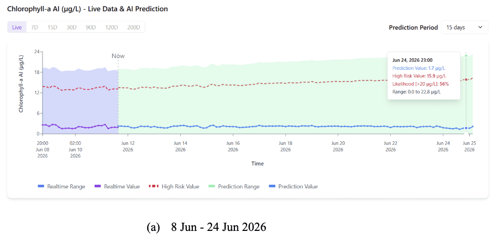
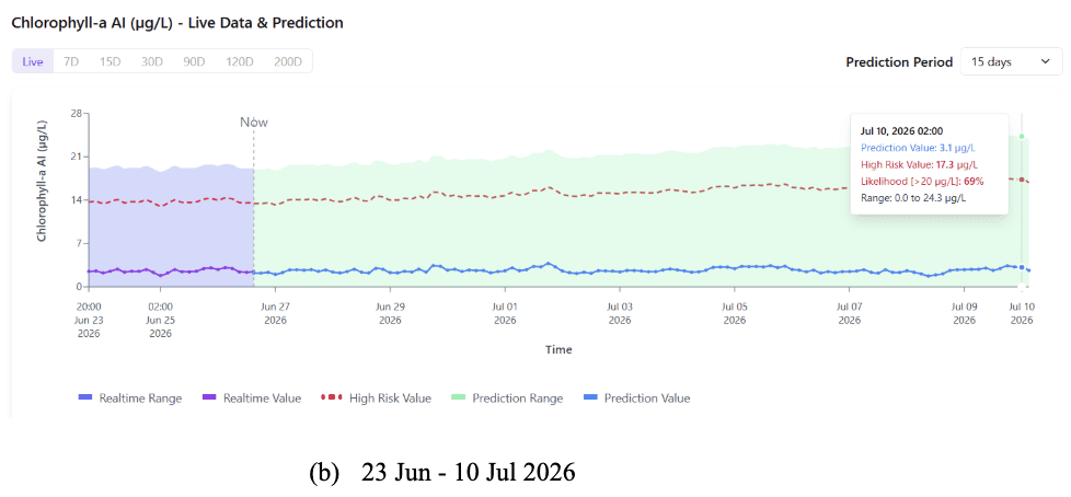
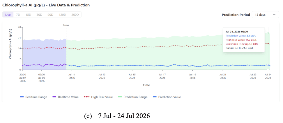
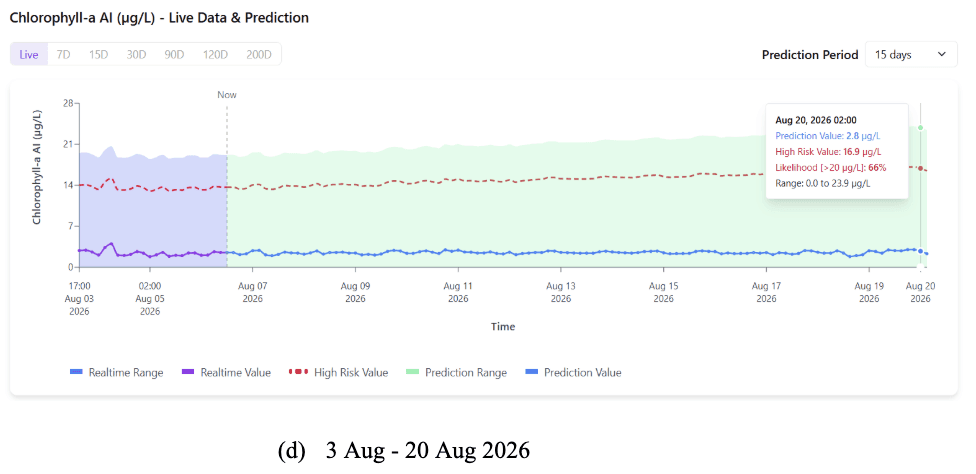
Source: AquaNurch Foundational Model (Twinity) output - Chlorophyll-a status, Peel Harvey Estuary.
EstuarySense is hosted on the Twinity Console, an AI-native platform which uses the AquaNurch Digital Twin Foundation Model and its latest outputs demonstrate the kind of real-time, predictive early-warning water intelligence capability that this article identifies as critical for managing emerging risks.
What changed over time:
Jun 8-24, 2026: Real-time chlorophyll-a remains low at approximately 2.0-2.5 µg/L. By June 24, 2026, the model projects a 56% probability of chlorophyll-a exceeding 20 µg/L, with the high-risk threshold rising to 15.9 µg/L, and the prediction range extends up to 22.8 µg/L.
June 23-July 10, 2026: Real-time chlorophyll-a continues to remain relatively stable at approximately 2.5-3.1 µg/L. AquaNurch Foundational Model forecast shows a more pronounced risk signal compared with the previous period. By July 10, 2026, the system indicates a 69% probability of chlorophyll-a exceeding 20 µg/L, while the high-risk threshold increases to 17.3 µg/L with and the prediction range extends up to 24.3 µg/L.
July 7-24, 2026: Observed chlorophyll-a remains low at approximately 2.8-3.1 µg/L. By July 24, 2026, the model projects a 68% probability of chlorophyll-a exceeding 20 µg/L, with the high-risk threshold increasing to 17.2 µg/L, and the prediction range extends up to 24.2 µg/L.
What are some recent key forecasts coming for the region :
Forecast Window - August 6-20, 2026: Current real-time chlorophyll-a remains low at approximately 2.8-3.0 µg/L, indicating that the estuary is presently operating within a safe range.. However, the AquaNurch AI Foundation Model’s 15-day continues to signal elevated future uncertainty.
By August 20th, AquaNurch Suite Models indicates a 66% probability of chlorophyll-a exceeding 20 µg/L, with the high-risk threshold projected to reach 16.9 µg/L. The forecast range extends up to 23.9 µg/L, and the predicted chlorophyll-a values show a slow but persistent upward trend, indicating that conditions favorable for algal growth may continue to develop despite the currently low observed concentrations.
This forecast is particularly significant given the eutrophic conditions of the Peel-Harvey Estuary and risk is further intensified by climate models now forecasting the establishment of a strong El Niño event, with Bureau of Meteorology seasonal outlooks indicating increased probabilities of unusually low rainfall and above-average temperatures across southwest Western Australia.
For an already nutrient-overloaded estuarine system like Peel Harvey, this translates directly into reduced freshwater inflow and flushing, higher water temperatures, increased stratification and decreasing dissolved oxygen levels, collectively creating conditions where algal proliferation can accelerate rapidly, increasing the risk of hypoxia or anoxia, loss of aquatic life and long-term impacts on estuary’s ecological biodiversity.
6 . Conclusion: Compounding, Not Isolate, Risk
The Peel-Harvey story illustrates a broader climate reality: It's not one problem. It's the combination of multiple pressures hitting at once.
For a catchment and estuary system that is already eutrophic, structurally drying, and sensitive to low inflow conditions, El Niño 2026 is a major climate event arriving on top of an already fragile baseline. The ecological consequences, lower DO, higher chlorophyll-a, greater algal bloom risk, oxygen stress on fisheries and benthic fauna and salt-wedge intrusion into the lower rivers, follow a well-documented chain of cause and effect. This is what climate scientists call compounding risk – where different stressors amplify each other.
In an El Niño year, predictive water intelligence becomes a frontline climate-adaptation tool. The question is no longer whether the region can monitor water quality, it is whether it can anticipate risk early enough to protect ecosystems, aquatic life, biodiversity and the communities that depend on the Peel-Harvey Estuary. Protecting the Peel-Harvey Estuary is not just about: Water quality, Fish populations, Tourism revenue but all of those, and protecting a sacred landscape that holds the story of creation itself
The health of Djilba is a cultural responsibility as much as an environmental one. The Bindjareb Noongar people have been its custodians for thousands of years, and their knowledge offers crucial insights for protecting it in a changing world.
References
Australian climate outlooks. (2026, June 18). https://www.bom.gov.au/climate/ahead/outlooks/
Brown, J., Zhang, X., Cahill, M., & Feng, M. (2015, May 14). The good-news El Niño story for Western Australia’s oceans. The Conversation. https://doi.org/10.64628/aa.ug53djqty
Condition - healthy estuaries. (2026, May 22). Healthy Estuaries. https://estuaries.dwer.wa.gov.au/estuary/peel-harvey-estuary/estuary/condition/
CSIRO. (2026, June 17). Expert commentary: El Niño. https://www.csiro.au/en/news/All/Articles/2026/June/Expert-commentary-El-Nino
Department of Water and Environmental Regulation, Department of Primary Industries and Regional Development, Bindjareb, Djilba, Evans, G., Thomson, C., Kilminster, K., Robb, M., Grant, B., Larsen, S., Beale, N., Van Looij, E., Hennig, K., Charles, A., Cousins, M., Kwinana‑Peel office staff, Phytoplankton Ecology Unit, Corporate Communications team, & Kate Hodge Environmental. (2023). Condition of the estuary 2016–19. In Peel‑Harvey Estuary. Department of Water and Environmental Regulation. https://www.wa.gov.au/system/files/2024-09/hewa-bindjareb-djilba-peel-harvey-estuary-condition-report-2016-19.pdf
Department of Water and Environmental Regulation & Department of Primary Industries and Regional Development. (2023). Water quality snapshot: Bindjareb Djilba (Peel-Harvey estuary) 2021–22 [Report]. https://www.wa.gov.au/system/files/2023-10/water-quality-snapshot_peel-harvey.pdf
Department of Water and Environmental Regulation. (2020). Bindjareb Djilba. https://www.wa.gov.au/system/files/2020-12/Peel_Harvey_Estuary_Protection_Plan_Bindjareb-Djilba.pdf
El Niño: what it means for Australia’s climate | The Bureau of Meteorology. (2026, July 1). The Bureau of Meteorology. https://www.bom.gov.au/news-and-media/el-nino-what-it-means-for-australias-climate
Expert Commentary: 2023/24 El Niño for Australia. (2023, September 20). CSIRO. https://www.csiro.au/en/news/all/news/2023/september/expert-commentary-el-nino
Gabi Warlang Bidi Water quality improvement plan for the Peel-Harvey estuary system. (2025). In Government of Western Australia. Department of Water and Environmental Regulation. https://www.wa.gov.au/system/files/2025-04/gabi-warlang-bidi-peel-harvey-wqip.pdf
Revitalising the Peel-Harvey Estuary. (n.d.). The Nature Conservancy Australia. https://www.natureaustralia.org.au/what-we-do/our-priorities/oceans/ocean-stories/restoring-shellfish-reefs/peel-harvey-estuary/
Leeuwin Current. (n.d.). CSIRO. https://www.per.marine.csiro.au/staff/Ming.Feng/Climate_impact2.htm
Long-range forecasts – weeks, months and seasons. (2026, June 18). Australian Bureau of Meteorology. https://www.bom.gov.au/climate/outlooks/#/overview/influences
Peel-Harvey River health - Healthy Estuaries. (2023, November 23). Healthy Estuaries. https://estuaries.dwer.wa.gov.au/peel-harvey-river-health/
Ross Marriott, The University of Western Australia. (2024, December 1). Historical impacts of a channel on estuarine water quality. ArcGIS StoryMaps. https://storymaps.arcgis.com/stories/7132fdded9de4d5e8e31a061d0f0051c
Stephens, R., & Morris, N. (2026, June 17). Climate change adding uncertainty to El Niño impact, scientists say. ABC News. https://www.abc.net.au/news/2026-06-17/climate-change-adding-uncertainty-el-nino-impact/106807260
Urbis. (2023). Economic evaluation of the Peel Harvey Waterways. https://peel-harvey.org.au/wp-content/uploads/2023/05/P0043213-Economic-Evaluation-of-Peel-Harvey-Waterways-Final-Report.pdf
What to expect in WA coastal waters and fisheries. (2023, July 10). Western Australian Government. https://www.wa.gov.au/government/announcements/what-expect-wa-coastal-waters-and-fisheries
Whisson, C. S., Wells, F. E., & Rose, T. (2004). The benthic invertebrate fauna of the Peel-Harvey Estuary of southwestern Australia after completion of the Dawesville Channel. Records of the Western Australian Museum, 22(2), 81. https://doi.org/10.18195/issn.0312-3162.22(2).2004.081-090